Key to photos

UPPER ROW (left to right): Avon Suspension Bridge; the Avon River meets the Floating Harbor; red doorway; view SW across the Avon R.; self-explanatory; Wills Memorial Building (which houses the Geology Dept); a 'crescent'; a narrow boat on the Avon Canal
LOWER ROW (left to right): Terrace houses; Banksy street art; downtown Bristol; the Matthew (a replica of a boat that Cabot sailed across the Atlantic); the Grain Barge (my favorite pub); my new neighborhood (new photos to come once I move); rowing on the Floating Harbor

Friday, November 1, 2013

From Fingal’s Cave to Inveraray Castle

I’m working backwards now, to early September, when niece Kathy and her fiance Josh joined me on a trip to Scotland. To Arnamurchan and (some of) the Inner Hebrides, to be more precise (see map). According to Wikipedia, The Inner Hebrides includes 35 inhabited islands and a further 44 uninhabited islands and the main commercial activities are tourism, crofting, fishing and whiskey distilling... well that’s a nice portfolio. The islands of the Inner Hebrides have a long history of habitation, with the Picts to the north and east, and the Gaels to the south and west (part of the ancient kingdom of Dalriada).  Apparently they became part of Scotland in 1266, and then were decimated by the Highland Clearances in the 19th century (I should do a blog on that sometime; it’s a very sad story).
We (Kathy, Josh and me, plus my colleague Steve and two graduate students, American Amy and British Emma) flew into Glasgow and drove north past Loch Lomond to Glencoe. I had visited Glencoe on my geology scouting trip with Jon and Mike in May 2012... it was fun to go back in a different season - we went for a short geology walk and then stopped by the visitor center, which featured nice exhibits on both the natural and human history of the region. In Scotland Glencoe is best known for the Glencoe Massacre... the history is complicated but I learned from my last trip that it was all the fault of the Campbells. I think the visitor center was designed by a Campbell, because the coverage of the massacre emphasized that the Campbells weren’t really to blame (Wikipedia has a long entry on the massacre for anyone who is interested).

From Glencoe we drove west to the coast and then took a small ferry to the Ardnamurchan peninsula. After which Josh had a crash course (not literally, luckily) in driving on one-lane (“single track”) Scottish roads. Josh was driving because now that I have been in the UK for more than a year, I can no longer legally drive on a US license (no logic - just a rule). And I haven’t found time to go through the process of getting a license (I need to do both the written and practical tests... my goal for the winter). The road meandered along the southern edge of the peninsula, passing through (for all you geochemists out there) Strontian, a tiny town that advertises itself as being the type locality for the element strontium - apparently the mineral strontianite was discovered in a lead mine north of the town. We drove to the western tip of the peninsula, to the Salen hotel, which advertises itself as being the westernmost hotel on the mainland UK. It featured a comfortable late Victorian bar and dining area with a nice view of the ocean; we chose it for its proximity to a lovely beach, excellent rocks, and a Stevenson lighthouse.

Which leads to one theme of the trip: the “Lighthouse Stevensons”, the title of a book that my Mom discovered and loved (she loved lighthouses in general), and a book that Kathy had been given by my sister Pat when she was going through Mom’s books. Kathy had read the book recently, although before our Scotland trip was planned. Josh was reading the book during the trip. The original lighthouse Stevenson was Robert, the grandfather of Robert Louis Stevenson (the writer). The Arnamurchan lighthouse was built by Alan, son of Robert and uncle of Robert Louis. The lighthouse was built in 1849 out of granite from the Isle of Mull (see below); it is 55m high and according to the lighthouse web site, is the only lighthouse in the world to be constructed in an “Egyptian” style. The light itself is now automated but is still maintained, and as a visitor you can climb all the way up and listen to an informative and entertaining overview by the current lighthouse keeper. He let us go outside to the (windy) viewing platform that circled the light, from which we had lovely views of the peninsula, and the islands.
After lunch and the lighthouse tour we explored the geology near the ferry dock (looking at impressive cone sheets - a geological feature I had read of but had never seen), while dodging impressive squalls. Which leads to another theme of the trip - an ever-changing pastiche of sunny and stormy weather.
 

At the end of the day we took another ferry across to the Isle of Mull, the Inner Hebrides proper AND home to its own single malt whiskey. The whiskey is named for the biggest town - Tobermory. The original name for the town, Ledaig, apparently means ‘safe haven’, and Tobermory does boast a nicely protected harbor. The current name apparently derives from the gaelic for ‘well of Mary’.... not sure if that is why there is a distillery here, but it is over 200 years old. The town itself can only be described as picturesque, with colorful houses framing the snug harbor.
Our first day on Mull we headed south and then west, along the “Ross of Mull” peninsula. The plan for the day was geology first and a tourist visit to the island of Iona second. The former was stymied by a flat tire... well it wasn’t the flat tire but the realization that Europecar (part of National Car rental) no longer supplies rental cars with spare tires! I’ll leave out the endless details, but good ol’ Steve said that we should see Iona, so he volunteered to deal with the endless phone conversations required to, ultimately, call the garage down the road to provide a new tire. The rest of us took yet another ferry a short distance across from the western tip of the Ross of Mull to the (truly) magical (small) island of Iona. The island was settled originally in the 6th century by St. Columba, and formed a stepping stone from Ireland to Scotland in the old kingdom of Dál Riata (Dalriada). It also played a critical role in introducing Christianity to Scotland, and is the origin of the famous illuminated manuscript the Book of Kells (now in Dublin).

The current abbey derives from the Middle Ages, although the modern structure is a pentimento of the layers of historical modification that are so common in Europe. The history is reflected and refracted throughout the present site in celtic crosses outside, and a lovely little museum centered around the high crosses of St John, St Oran and St Matthew.


After spending a few hours wandering around (we all agreed that we would have liked to stay for a few days to truly explore), took the ferry back to Fionnphort, a small town perched on spectacular red Mull granite (as in the Arnamurchan lighthouse), where Steve was waiting for us with news of a newly tread car.

 
There was still time in the day for a scenic geology stop on the south coast, thanks to the still long days and lovely weather. A major benefit to doing geology is the excuse to wander off the beaten track, in this case to lovely little bays and beaches that line the southwest coast of the Ross of Mull. And then the drive back to Tobermory, with the wonderful high latitude light illuminating the landscape.


The next day we split up, with Kath and Josh deciding to climb Ben More, the highest peak on Mull, while the rest of us hiked up from Loch Ba to see some spectacular deposits that form a ring dike around an ancient caldera (formed at the time that the North Atlantic opened, in response to initiation of the Iceland plume). It was a lovely day for a hike, with sun and mostly clear skies providing lovely views of most of the island.
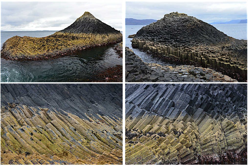
Our final day on Mull dawned gray and rather damp, but luckily the rain held off long enough for us to enjoy our last day in the islands, a day that revolved around a boat journey around the small islands just west of Mull. This is a trip that I had been wanting to do for quite awhile, because it included a trip to Staffa, and Fingal’s Cave. Like Giant’s Causeway, Staffa is formed from spectacular basalt columns; Fingal’s cave is not quite as touristy because of its remote location, but has featured in an orchestral piece by Mendelssohn (which, of course, every tour boat plays when circling the island). The name is from an 18th century poem about ancient Gaelic myths that tells of the hero Fingal (Fionn mac Connell) building a bridge from Giant's Causeway to Staffa.  I’ll let the photos speak for themselves.


After our day on the water, we drove back across Mull and hopped on yet another ferry, which transported us to the mainland town of Oban, home to another eponymous distillery. This is where Steve left us (his brother lives in Oban). The rest of decided to visit the distillery the next morning before heading back to Glasgow, but the morning tour was full. We did wander around the small museum, and purchased some whiskey (Steve had orchestrated a whiskey tasting one evening in Tobermory... we all decided that Oban was our favorite), before making our way south to Inveraray, home of Inveraray Castle. Which all you Downtown Abbey fans will recognize as the location of the final episode of Season 3, the trip to the highlands. It’s not an old castle (like the one I stayed at near Durham) but instead is an 18th [?] century mansion constructed in the form of a Sleeping Beauty style castle. Entertaining to look around, and had a nice little cafe that served (among other things) warm soup for lunch. And the grounds provided a nice setting for a stroll and a group photo...

Saturday, October 19, 2013

I slept in a castle

Brancepeth Castle, to be exact [http://www.brancepethcastle.org.uk/index.html]. It is a real castle, privately owned, and bears the imprint of a long and varied history:
the home of the Nevilles, who featured prominently in the War of the Roses); it was then confiscated by the first Queen Elizabeth... 
• the home of the Russell family (coal barons) in the late 18th and 19th centuries
• barracks during WWII (the mark of which is an ugly appended bathroom block on one side of the building - you would have thought that a 200 room castle would have been sufficient for the army needs)
• a Pyrex laboratory, where they used the larger rooms as laboratories - maybe this explains the extent of gray 1950s linoleum on the floors
• home to a private family since the 1970s... some of the basement rooms serve as a book repository for boxes of books from the old family publishing business
• apartments for random folks, including my host Richy Brown in the geology department at Durham University... which is how I ended up there.

I was in Durham as the external examiner for a PhD thesis. Durham is 4 1/2 hours by train from Bristol, a train journey that heads north to Birmingham and then diagonals northeast across the rolling green midlands, and through the northern cities of Leeds and York before reaching the small cathedral town of Durham. I arrived in the dark and rain; it was nice to be met by Richy at the station and taken to dinner before we drove five miles to Brancepeth Castle. The castle forms the locus of a small town with a line of neat brick houses but no amenities... not even the near-ubiquitous country pub. After dropping my things in Richy’s apartment, he took me on the “ghost tour” of the nether regions of the castle, armed with an LED flashlight. The first stop was at the vampire kit on the wall (break glass in case of emergency to reach garlic or the cross, whichever best serves your purpose!). And then through the musty basement rooms piled with boxes of books, floored with rubble and apparently sometimes home to bats. The basement tour was followed by a brief tour of some of the grand and partly renovated rooms of the main floor en route to my home for the night. My room lay along a gray linoleum hall; it was large and sparsely furnished with very tall ceilings, lovely tall wood-framed windows and a bed warmed by an electric blanket and cozy blue and white checked comforter (but I didn't think to take a picture).

The next day I awoke in the dark to clear skies and Venus twinkling through the grand windows. After a shower in the (modernized) WWII bathroom block I found my way through the maze of ground floor rooms and up the stairs to Richy’s apartment for breakfast. As the sun gradually came up (Durham is noticeably farther north than Bristol), I requested a daylight tour of the interior, followed by the exterior, of the castle before we headed in to the University...


Chad’s visit to England
Working backwards... during the second week of Octobern, nephew Chad visited, en route home to California from the country of Georgia, where he had just spent six weeks doing field work. He arrived in London on a Sunday morning, have flown overnight from Tbilisi. I met him in Paddington station in London (near the bronze statue of Paddington bear). Although clearly tired, Chad managed to stay awake all day, enjoying the luxury of being in a country where he not only understood the language but also recognized so many familiar places and names. 
We wandered along the south bank of the Thames (and laughed at a little Mexican restaurant called Wahaca - clearly they had given up with the Mexican spelling!), crossed the Jubilee bridge near the London Eye and admired Westminster and Big Ben en route to Regent Street, where we met Alison and Mark for lunch at Nopi restaurant - run by the chef Yotam Ottolenghi, the author of our favorite cookbooks (Chad and Emma both got Ottolenghi cookbooks for their birthdays). Then a stroll back to the south bank and time for Chad to take a shower before we all re-convened at the Globe Theater for a production of Macbeth (known here as “The Scottish Play”). We ended the evening with a beer at the George, an old coaching tavern that is now run by the National Trust.

Chad and I spent Monday in London.. more walking exploration and then a boat trip down the Thames to Greenwich. We started to walk to the Observatory, but couldn’t resist visiting the renovated Cutty Sark on the way. The allure of boats. But we did learn some good trivia about the boat, the best of which is the origin of its name. Apparently from a Robert Burns poem, “cutty sark” is a Scottish term for women’s undergarments! Who would have guessed? After lunch we climbed the hill to the Greenwich observatory. On a gray Monday morning in February, the observatory was pleasantly quiet. Not even a line for a 0˚ meridian photograph! And plenty of time to admire the view, and the stark contrast of new and old that pervades London (well, everywhere I guess, but somehow the contrast is much more dramatic in London than elsewhere).


The other day of note during Chad’s visit (well, maybe I should say the other day of photographs) was our trip to Stonehenge. We embarked upon the trip at Susie’s recommendation, which included walking to Stonehenge from the small town of Amesbury, about 3 miles east of the site. The area around Stonehenge is now managed by the National Trust, which has developed a trail system that includes several of the archaeological sites of the region. The trail follows the contours of the downs, the flint-rich chalk formation that yields material for tools and stone walls in addition to imparting the charcteristic rolling hills. We were surprised to find that Stonehenge itself lies only on a local high, but below the surrounding hills, so that some of the first views of the stone monument are from above. Another surprising feature was the sheer number of manmade landscape features - mostly barrows (we only half-joked about barrow-wights in memory of Tolkein).

But Stonehenge itself really is impressive, despite the highway that runs just below it,
the ubiquitous busloads of tourists, and the almost cliched first view of the stone circle. We made one circuit with the audio tour and cameras, and then made another circuit just to soak up the sense of place.


After a picnic lunch near the parking lot (and surrounded by starlings, which Chad and I decided were actually much more spectacular birds that the North American pests... perhaps it is just that they thrive in their home environment) we continued on the barrow trail, and then back along parts of “the avenue”, the original uphill entrance to the site. By then the clear skies of the morning had given way to a ceiling of white fluffy clouds, and the air had the crispness of fall (or autumn, to use the British phrase... I am always teased when I use the term "fall").


Sunday, June 30, 2013

Gromits invade Bristol

After months of anticipation, the painted Gromits have arrived. I spotted my first one yesterday while sailing... it was aboard the Mathew and is decorated with a map of the world. Then the largest blue&yellow water taxi cruised by, with a Gromit in the bow. And then when I walked home I saw that even my local Pump House has a Gromit. So at that point I grabbed my camera and went for a short exploratory walk. I'll add more pictures as I collect more Gromit sightings. 


Cumbria Way


Three northwesterners (me, sister Sue and brother-in-law Harvey) explore the Lake District. We did this by hiking the Cumbria Way, a 76-mile-long networks of (mostly) footpaths, lanes, etc that traverse the Lake District from north to south to the west of the more populated parts of the lakes. We stayed in B&Bs and had our bags tranferred, so we were able to carry only day packs - a real pleasure! I kept a rather cryptic diary en route ... this is a slightly edited version.


 June 14  Ulverston

Rain thundering down on the roof of the Old Bakery House. Pint of prawns for dinner plus my share of sticky toffee pudding.  A bit of a walk would have been good but we rapidly retreated from the rain - we will probably walk in enough rain in the week to come. To reach Ulverston we had traveled north by train, changing first at Birmingham and then Lancaster, passing fluorescent yellow rape fields hedged by Looking-Glass hedges and small not-very-attractive towns of identical brick houses that transformed into more pastoral countryside as we moved north. Arrived at Ulverston in the mid-afternoon, with its red-and-green trim iron grillwork station and sign for the Cumbria Way. Ulverston is a neat stone-faced town with purple flowers dripping from gray walls; the Mercedes dealer, Audis, and BMWs speak to its affluence. Our accommodation for the night is a ‘self-catering’ cottage with a stone front and bright red door and chic black-and-red themed interior.


June 15  Ulverston to Coniston

Although we started the day thinking that we might catch a taxi out of Ulverston to shorten our first day (15.5 miles), we were shamed into walking the entire way by our Sherpa Van contact, the drum player Martin. He showed up this morning with red shoes and red jacket and funny black hat - attire for a gig with his New Orleans jazz band later in the day. To explain, Sherpa Van is a company that will transfer bags from hotel to hotel. After trying it I’ve decided that it is definitely the way to go - 15 mile days are actually OK if you are carrying only a day pack! It then took us a little bit of time to find Cumbria Way (this became a theme to our journey, that getting out of town was commonly the biggest navigation challenge of every day), but a nice man directed us to the trail head, which was nicely marked once we got there.

The Cumbria Way, as a trail, is as varied as the landscape it traverses. In the pastured region north of Ulverston, the trail traversed pastures and wandered through farmhouses, the route sometimes obscure but well delineated on the 1:25,000 scale Ordinance Survey maps that are the classic British walkers’ guide. The maps can be a bit cumbersome (and required constant refolding as we moved along) but the detail is remarkable, as every farm house and fence line is indicated. The Cumbria Way was also marked by yellow arrows, and sometimes wooden signs that became our beacons and guide.


The first day’s weather is dramatic, with fast moving clouds sweeping sunlight across the green fields. We pass pastures of cows and sheep and dry stone walls that intersect at picturesque stone farmsteads. The landscape is gridded with blooming hedges and flanked by fields of yellow buttercups.

As we approach the Lake District proper, green pastures transform to bracken, tarns and black peat bogs torn up by range animals and mountain bikes. It is here that we realize that the OS maps are not only our guide to the trail but also an introduction to the pentimento of language embedded within the local names. For some I even recognize their nordic roots because of similarities to Icelandic: dale = valley (Icelandic = dalur); fell = mountain (Icelandic = fjall); waterfall = force [Icelandic = foss]. But it is the sheer abundance of descriptive names... for water: beck [stream], gill [or ghyll; ravine or creek], tarn, water [lake]; for knobs-mountains: how(e), height, knott, pike, rigg [ridge]; for landscape: moss [bog], thwaite [clearing], coppice [managed woodland]. And so we pass Wool Knott, Slatestone Fell, Beacon Tarn and Tarn Riggs, but our favorite of the day was (of course) Standing Harvey Moss, which we reached just before descending to Coniston Water.


Blustery winds create whitecap froth and blow a lovely boat toward Coniston. We were all excited to see Coniston, particularly as we had a view south to Peel Island [read Wildcat Island, Swallows and Amazon fans]. However, the walk north along the lakeside was not quite the stroll we expected because of rocky paths and some topography, until we reach the open expanse of woods that is Torver Commons. And then there were boats and tents and all of the scattered signs of summer and tourists, although Coniston Water is surprisingly undeveloped relative to neighboring Windemere. Coniston itself tucked into a valley away from the water, with cliff dwellings (my term0 of stone that hug the hillsides below the Old Man of Coniston [Kachenjunga to the Swallows] and other glacier-sculpted peaks. We find our rooms at the Crown Hotel and then head off in search of Coniston-brewed Infinity IPA and dinner. The most curious local tradition of the Lake District (to us at least) is the invitation for dogs to enter pubs. Quite understandably, then, there are lots of dogs, and some temporary fights. But we made friends with Portia the red fox lab - seemed like a lovely dog.

June 16   Coniston to Old Dungeon Ghyll

We left Coniston on a leisurely schedule that set the tone for a leisurely day. The Cumbria Way was much easier to follow today - only occasionally did we even need to check the map, the path now etched into the landscape and paved by stone most of the way, sometimes loose gravel to cobbles, sometimes neatly laid stone paths, who knows by whom. The hike north from Coniston followed valleys, through the Monk Coniston estate (complete with designer medieval dog kennel and friendly National Trust guide), past the Tarn Hows (where we entered the Borrowdale volcanic rocks so I felt at home). Then followed Greenburn Beck with its multi-tiered waterfalls at Colwith Force to Elterwater and a ginger beer at the Brittania Pub. Then an easy walk along stone-walled lanes and pastures to first New, and then Old Dungeon Ghyll. Entertainment along the route was provided mostly by sheep. They come in all flavors here. The white-headed gray sheep with cute black lambs (we discovered that they are the classic Borrowdale breed, Herdwick), the white-headed brownish sheep with white lambs... the lambs that have evolved to trot along the top of stone walls (so what are the walls for?). And of course, the occasional calf and cow.


And then there is the variety of walls - dry stone or cemented, neatly arranged or helter-skelter, mixed in rock type, mixed in rock form, and neatly laid slate. And the endless variations on the mode of decorating the top of the walls. 

But there's also the vegetation (flowering wild garlic and hawthornes, cultivated rhododendrons in all hues, the lovely elegant space-filling sessile oaks, the larches and elderberry) and birds (did we really see a gooseander today? Sounds like a joke but it appears in my bird book as similar to but larger than a merganser, which is what it looked like. And at the end of the day the sun came out just in time for an outside beer at the Hiker's Bar at the Old Dungeon Ghyll hotel, an indoor dinner and then time in the lovely comfortable resident's lounge with its comfy couches and eclectic old prints on the walls.


June 17  Old Dungeon Ghyll to Rosthwaite


Damp morning but rain had stopped by the time we were ready to leave Old Dungeon Ghyll. Walked up Great Langdale and then climbed the stone path that switchbacks up Stake Gill, which tumbles down the headwall of the valley. The stream bubbles cheerily alongside, the ever-present sheep with tie-dyed wool. We also learn that sheep skins provide an impermeable barrier for repairs to boggy parts of the trail system. We are accompanied on the first part of our walk by an American Anglophile who was more of a Swallows & Amazons afficionado than the Cashmans... told us the location of all the books and something about Ransome, as well as the original Holly Howe (now self-catering cottages).


Climbed out of Great Langdale and over lumpy ground (moraines) to the "Pile of Stones" that marks the divide at Stake Pass (472m). Conversed with fellow walker Aussies who wanted confirmation on their map reading... which led to a discussion of different ways of viewing the walk. The Aussies described themselves as taking a point-to-point approach (yellow arrow to yellow arrow), as described us (the geologists) as having the big picture perspective. They were finding the point-to-point approach a bit disconcerting, because today was almost devoid of little yellow arrows, surrendering instead to a stone path through the treeless grass and bracken that needs no identification. However, we noted that they were better at finding their way out of the towns! Descended along Stake Beck to Langstrath Beck and finally Borrowdale, as lush and green as its fame for being the wettest place in the UK would imply. Glimpses of sun illuminate the hill slopes which continue to have a lumpy character and convexity that amazes geomorphologist Harvey. As we descend we start to pick up trees of elderflower and hawthorne and finally the majestic sessile oaks and yews that give their name to farms in multiple valleys. Stop for lunch at a waterfall partway down the valley wall; stop for another break at a Hunts Mills style waterfall where Sue and I play with photos.


Walk into Rosthwaite [clearing among the rose thorns] to find the nice and welcoming Scafell Hotel. Retire quickly to the Riverside Bar with pints of Copper Dragon beer. Soon joined by our Aussie friends although they are staying up the road (but were in need of a pub for dinner). Settle in for a quiet and rather gray overcast evening, my room looking up the valley over a rhododendron garden and oak-lined beck.

June 18  Rosthwaite to Keswick via Catbells


A glorious sunny day in the rainiest place in England. Lovely walk down Borrowdale, past the Herdwick sheep. Getting out of the valley meant that we were back to stone walls and their necessary counterpart stiles, which come in as many different styles as there are Herdwick sheep colorings. Not to mention all the ways devised to cross gills, becks, and rivers.


Part way down the valley we made the decision to divert from the Cumbria Way to climb Cat Bells, a craggy peak with an unlikely name that derives from a mispelling of the nordic word bield, which means den (from the belief that the fell once was home to wild cats). An impressive staircase on the way up, a steep descent over polished stone. But lovely views of Derwentwater in one direction and Newlands valley in the other.


The lake was full of water craft - sail or paddle plus the attractive polished wood launches that buzzed around the lake. Fleets of red canoes, white-sailed small sailboats and the occasional red-sailed Mirror dinghy. After a leisurely lunch at the summit and a sometimes knee-painful walk down, Sue and I decided that we wanted to get out on the water via the ferry, while Harv decided to keep walking. We had a pleasant boat ride and time to check out the rowboat hire facilities (and National Trust shop) before meeting up at the Badgers Rest B&B in an attractive stone-faced terrace house. Shower and then out to the Bank Tavern for beer and dinner, followed by a stroll around this town, where every other store is a high tech mountaineering establishment. Still sunny at 9, still very light at 10, as we approach the solstice at >54˚ N.

June 19  Keswick

A gloriously sunny day. Our B&B didn't serve breakfast until 8:30 so we decided to walk to the Castlerigg stone circle before breakfast. But we had a few problems finding our way, and it was a bit farther out of town than we thought, so we didn't quite get there before breakfast. We did return after breakfast and it was excellent. Perched on the top of Chestnut Hill, backed by the northern fells and facing on Derwentwater. Not surprising that this place was special. Circle was not quite a circle and the large stones of the Borrowdale volcanics were irregular in size and shape, so it is thought that this is a fairly old stone circle (4500 yrs). I wonder if part of the motivation for making it was the glacial erratics scattered around the landscape. National Trust signs about the site were interesting. We particularly enjoyed the story of Dorothy & William Wordsworth & Samuel Coleridge visiting in 1799 and complaining that there were too many tourists so that it spoiled their contemplation of the site.


By the time we got back to town we were starting to think about lunch, which we had at a little vegetarian place that fronted on the large parking area rather than the main street, and was therefore quiet. Then off to the Cumberland Pencil Museum and a very enjoyable few hours touring the museum, taking a free pencil watercolor class, and, of course, then buying some supplies! The most surprising information from the museum was learning that graphite was so valuable, particularly when in a form that could be shaped into pencils. It eventually required an armed escort, up until the French figured out how to mix clay with inferior graphite and thus bind it into shapes. But Derwent fine art pencils are still a thriving industry (they have made commemorative pencil boxes for the recent royal weddings, for example). And I liked the stone wall outside of the museum, which looked rather pencil-ish.

Later in the afternoon we decided that we needed a proper British tea, so went down to the lake to find a nice tea garden and enjoy the sun. Unfortunately we were too late to rent boats (just when the wind had dropped to the point that it would have been perfect for rowing) but we went for a short walk and enjoyed the water and sun for a bit before returning to the B&B, and then back to the Bank Tavern for dinner.


June 20 Keswick to Caldbeck

Woke to more glorious sunlight. Set out from Keswick right after breakfast and headed north. Immediately clear that this would be a different day, with slate underfoot and sheep that reversed color (black heads and white wool rather than the Herdy white face and colored wool... entering a new sheepshed, we joked). Trail headed uphill for a ways and then contoured pleasantly around the hillsides. With the wind at our backs, the path sandy rather than rocky, and the view of the smooth bracken- and heather-covered hills so different from the knobby irregularities of the volcanic mountains, the walking was the most pleasant of the journey. The only thing to mar the walk was the progression of mountain bikers who tended to sneak up from behind with very little warning.


The human-constructed landscape was also different. Stone walls were less numerous and mostly apparent only in circular sheep folds (nouveau stone circles, Sue and I called them). Also apparent were the occasional ruins of what looked like sheepherder cottages, and, as we turned up the valleyto ascend to the ridge, the ruins of, and tailings from, a large mine. The only functional buildings we passed were the Skiddaw YHA, improbably located in the middle of nowhere (well, not really - was only a couple of hours walk from Keswick but definitely a walk or mountain bike ride) and a tar-paper-covered hut on the ridge (which also hosted the only yellow Cumbria Way arrow on the entire trail across the high fells). The trail took us up across High Pike, one of the ‘Wainrights’. Another theme of the trip was the history of climbing, or running, the fells. This past-time has become an obsession for many people, one of whom (Wainwright) produced phenomenally detailed descriptions, maps and drawings of numerous (100s) climbs in the Lake District. So - High Pike is one, Cat Bells is another. Harv bought a map of the Wainrights (complete with checklist) and dutifully entered our names for both.


The Cumbria Way was rather free-form across the top of the northern fells, but basically followed a crow’s route (or, I should say, jackdaw  - common crow’s cousin here but a new bird for us), descending steadily across grassy slopes and straight into the fields and settlements of Caldbeck. Arrived at the wonderful Old Rectory to barking dogs and a big pot of tea and cake in the comfortable kitchen, and large airy rooms and strong hot showers and comfortable pub meal.


June 21 Caldbeck to Carlisle

The day dawned overcast and we were tired from the previous day. Hard to tear ourselves away from our spacious Old Rectory home. But after a large and tasty breakfast in the OR kitchen and time to chat and organize, we headed down the driveway, over the stream and off along the Cumbria Way. Again a very different day. The walk basically followed the River Caldew all the way to Carlisle, first through muddy green woods and then across buttercup-carpeted pastures. Found a convenient log by the river for lunch, watched fish, great blue herons and swans, passed through pastures of cows as well as sheep (a sure sign of the lowlands) and stopped at Bridge End for tea/ginger beer/scones and a rest for aching feet. The pub had a TV that was showing the races from Ascot. We'd been seeing photo headlines in the papers about Ascot - particularly the hats worn by attendees in the royal box - and Tim Cartmell (from the Old Rectory) had given us the news that the Queen's horse had won a race on the first day, but other than that we hadn't paid much attention to the horse racing. But since we were there we decided to stay to watch a race... a mile, once around the impossibly green grass track, and a stunning race. The horses were closely clumped throughout most of the race, with the single gray horse Sky Lantern at the back of the pack. Until the home stretch, when she had an amazing run up the outside to win by several lengths. Quite exciting!


Just north of Bridge End is the little town of Dalston, which is where our Ordinance Survey map ended. We asked around to try to find a source of another map without any success. But we did find a guy in the post office who pointed us to the bike path that served as the final 5 miles of the Cumbria Way. Hard on the feet to walk on pavement but easy to follow, as it hugged the river through abandoned textile factories, along the railroad, across a preserved wetlands and into the suburbs of Carlisle. Renovated brick mill houses that had clearly been associated with the mills, cobblestone streets contrasting with the satellite dishes outside the doors, houses precariously located relative to the river walls and labeled flood gates. In fact, all along the river we could see evidence of a large recent flood in the form of LWD (large woody debris) stacked against standing trees and bridge support, gravel on fields. Finally arrived in Carlisle and made our way through town with turreted towers flanking red sandstone walls, up the hill to and across the River Eden to our hotel. Which is most notable for being located not only directly on Hadrian's wall but also on the site of the largest Roman fort along the wall (10 acres; 4 hectares). Of course you can't see any of the fort because the ruins now lie below the city, but apparently there has been sufficient excavation over the years to map out its extent. Remarkable when you realize how far away Rome is!

June 22 Carlisle to Bristol

 We spent the morning exploring Carlisle, which meant reading the sign about the Roman fort and then going to visit the castle. Both underlined the theme of Carlisle, which is that it has been a borderland (between England and Scotland) for a very long time! But on reflection, it is the visions of countryside that will stay with us, the green pastures gridded irregularly with stone walls, only partially successful at enclosing sheep but a quintessential element of the British landscape.