Key to photos

UPPER ROW (left to right): Avon Suspension Bridge; the Avon River meets the Floating Harbor; red doorway; view SW across the Avon R.; self-explanatory; Wills Memorial Building (which houses the Geology Dept); a 'crescent'; a narrow boat on the Avon Canal
LOWER ROW (left to right): Terrace houses; Banksy street art; downtown Bristol; the Matthew (a replica of a boat that Cabot sailed across the Atlantic); the Grain Barge (my favorite pub); my new neighborhood (new photos to come once I move); rowing on the Floating Harbor

Sunday, September 11, 2016

BRISTOL STAGE - TOUR OF BRITAIN

Two stages of the Tour of Britain were here in Bristol yesterday... turned out to be easy access, so after the first few laps of the circuit race from close to my house (just beyond the Pump House, for those of you who know Bristol), I decided to move around... this post is just photos (and maps).


Sunday, July 3, 2016

Exploring the Neolithic in the Orkneys

I just returned from five days on “the Mainland”, the largest of the Orkney Islands, and was sufficiently inspired to resurrect my poor neglected blog. The Orkneys lie about 15km NE of John o’Groats, the northeastern corner of Scotland. At c. 59˚N, the days are very long at this time of year, and we were lucky to have them also partly sunny. “We” are a crew from Oregon - Jim O’Connor, his wife Karen Dempsey and daughter Anna (who just graduated from St. Andrews, thus providing Karen and Jim with an excuse to come to Scotland), and Andrew Fountain and his wife Virginia Butler, professors at Portland State University who are in Bristol for 5 months. They had planned a trip to the Orkneys, which I’ve wanted to visit for years, so I decided to tag along.

The Orkneys are best known for their wealth of archaeology - including the Heart of Neolithic Orkney UNESCO World Heritage site. It also has 13 RSPB (Royal Society for the Protection of Birds) reserves. So our 4.5 days of exploration felt as if we had only scratched the surface... and then there are all of the other small islands. So I’ll have to go back. Below is a brief overview of some of the amazing places that we visited. 

THE HEART OF NEOLITHIC ORKNEY comprises several different Neolithic monuments that lie on an isthmus separating the Lochs of Stenness and Harray. The Ring of Brodgar is one of the youngest, at 2000-2500 BC (about the same age as Stonehenge). It a large (104 m diameter) stone circle surrounded by an outer ditch that was dug into the sandstone bedrock. Of the original 60 stones, 27 are still standing; others are collapsed or missing altogether. 


Southeast, and past the narrowest part of the isthmus, are the Standing Stones of Stenness. They form a much smaller circle than the Ring of Brodgar and originally contained only 12 stones, but the stones are taller (up to 5.7m) and dramatic with their angled tops. The stones in both circles derive from the Old Red Sandstone that forms most of the islands; more specifically, the Stromness flagstone, which explains the tall thin stones. This stone circle is thought to be older than the Ring of Brodgar at c. 3000 BC. A major occupational site of the same age - the Ness of Brodgar - was discovered in 2002. Excavations are ongoing, but have included not only amazing stone buildings but also decorated pottery and the first evidence of Neolithic wall painting! Unfortunately, this season’s excavations will start next week, so we couldn’t see them. 

Other structures in the area include the Barnhouse settlement, a cluster of at least 15 circular houses that also dates to 3000 BC, and Maeshowe, one of the largest burial mounds in Neolithic Europe. No photos because photos weren’t allowed inside. It was built around 2500 BC of truly massive stones, which build upward to a corbelled ceiling. Like Newgrange in Ireland (its rival for the “largest” claim), it is aligned toward the setting sun in midwinter so that the setting sun shines between two hills on neighboring island Hoy and illuminates the interior of the  tomb as the light travels up the narrow entrance tunnel. It makes sense to me that the people here would want to mark the winter solstice as the point where light starts to return. The flipside, of course, is the length of the days in the summer; my sunset photos were taken at about 10:30pm. 


SKARA BRAE  The most famous Neolithic site on the island is Skara Brae, an extraordinarily well preserved settlement that was abandonned c. 2500 BC. It is really amazing - feels like you could move right in. And makes you realize that 5000 years is not much in the scheme of human history. The homes come complete with beds demarcated by stone slabs (and including a little nook in the adjoining wall for a bedtime book [the latter is my interpretation], shelves made of stone, a large central hearth, inside passages connecting the individual houses, and even inside plumbing (well, certainly drains to control the runoff from the shallow bedrock). 


THE CAIRNS PROJECT  The amazing thing about the Orkneys is that archaeology doesn’t stop in the Neolithic, but is nicely layered to the present. The next substantial structures that dot the landscape are the Iron Age brochs, built sometime after 500 BC. They are round drystone towers that were originally up to 10m high and thought to be defensive, at least in part. The first one that we visited is an active excavation by Martin Carruthers, a researcher and teacher at the  Orkney campus of the University of the Highlands and Islands (I love the name!). Virginia contacted him ahead of time, and he gave a fabulous tour and explanation of the site, which includes not only the central broch but also encroaching and overlapping later settlements outside the original walls. The broch walls are 5 m thick; the interior diameter of the central structure is 11m. So far, their dates put it at 140-190AD, which overlaps with the Roman occupation of Britain. The site is rich with artifacts. It also has a somewhat different astronomical feature - a hole in a stone that is oriented for the autumn equinox, at which point the sun projects through the hole onto a flat stone behind. Thus is appears that for these agricultural people, the harvest was the most important time to mark. Another interesting feature (apparently common to other brochs) are spiral stairs that lead down to subterranean caverns; perhaps storage, but also perhaps ceremonial. One indication is that the stairs are anti-clockwise, in contrast to aboveground stairs that spiral upwards in a clockwise direction.


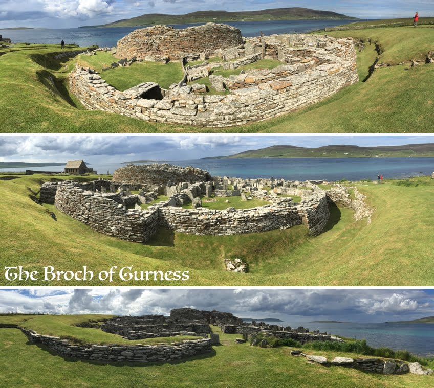
BROCH OF GURNESS  A nice complement to the Cairns dig is the Broch of Gurness, an Iron Age Broch that has been “prettied up” for tourists. The semi-circular ditches here are similar to Iron Age forts in SW England, and were constructed c. 400 BC; the broch was probably constructed around 200 BC and abandonned c. 100 AD. 


After this time, like the Cairns site, it hosted numerous surrouncing Pictish farmhouses. These are followed by a single 9th century Viking grave.


BROUGH OF BIRSAY  As far as I can tell, “broch” and “brough” are the same word... but here on Birdsay there is no broch but instead the remains of two Viking settlements and one 12th century church, as well as some Pictish artifacts. The Picts as a confederation of northern Scottish tribes were first described by the Romans in AD 297, so that seems to be the earliest date ascribed to them, although they clearly descended from the broch builders. They are thought to be ‘celtic’ (although that is a vague term), as demonstrated, among other things, by the style of their carvings (including the stone here). When the Vikings arrive from the north in the 9th century, this outpost became an important stronghold of Earl Thorfinn Sigurdarson; his story is recorded in the Orkneyinga Saga. The Norse habitations are oval-shaped, and contrast with the rectilinear form of the 12th century church (probably Benedictine or Augustinian. The brough lies just below a headland on a tidal island that is accessible for about 4 hours around high tide. 


The island is capped by a Stevenson lighthouse that warn of the low-lying skerries around the island.

Perhaps most fun for us were all the seabirds - it’s nesting season, so the cliffs are decorated with nesting gulls, pigeon guillemots, razorbills, terns and puffins.  There were also skuas and eider ducks plus, I’m sure, a lot of birds that I missed!


The coast around Birsay also provides hints about the origin of the distinctive slant to the standing stones, as the flagstones here are fractured into remarkably geometric patterns. And history continues and merges past and present. The Birsay coast is home to a “geo”, a small harbor used to both launch and store boats in, what are now, grassy hollows. Here we also found whalebone as scuplture and picnic wind protection of a form remarkably similar to Skara Brae houses. 


Striking coastal sandstone cliffs are not limited to the north; they can also be seen in the southeast coast, particularly around Yesnaby.


Another important chapter in Orkeny history came with the world wars, which used the Scapa Flow, a large protected body of water south of the Mainland, for the British naval fleet and, after WWII, as a place to scuttle captured German vessels. Although there has been some salvage, the rusting hulks of some of the ships can still be seen in the shallower parts of the bay. On a more uplifting note, a popular tourist stop is the Italian Chapel, on the island of Lamb Holm (now connected to the Mainland by a road). It was built during WWII by Italian prisoners, and has beautiful painting inside with remarkable trompe l’oeil tiles, columns and other decorative elements.

A few photos of the present. The composite below has various random components. In the center, peacefully sleeper is John Rae, a doctor and arctic explorer who found the last part of the NW passage and figured out the fate of the Franklin expedition. Although he was FRS and FRGS (geographical society), he was shunned by the British establishment because of his report that the Franklin expedition had resorted to cannibalism (which went against the glorification of the expedition by Lady Franklin. So instead of being buried in Westminster Cathedral like other famous British explorers, he is buried in the Kirkwall cathedral - we think that he got the better deal, because he looks so comfortable. The other photos are of the Orkney Brewery, which makes Corncrake Ale, Raven Ale, Orkney Gold, 3 Sisters Ale and, as you can see, Skullsplitter Ale, which speaks to the Norse heritage. Which leads to another interesting story... the transfer of the Orkneys from Norway to Scotland in 1468 as part of the dowry of Margaret, daughter of Norwegian king Christian I, for her marriage to James III of Scotland. On the left are a couple of views of the town of Stromness, from the "Harray Potter" to the peaceful evening scene (photographed at about 10:30pm).

Finally, there is my Orkney home - the Castlehill guest house, where hostess Denise provides abundant really good food, dispenses information about the islands and generally hosts a revolving international gathering of guests. She is shown here with her son’s dog Oscar and German guest Andreas; Andreas and his wife Sabine (below) were there for the entire time that I was, and provided fun company and interesting dinner conversation.

Tuesday, March 31, 2015

Travels with an artist in Iceland

... have given me a new perspective on the Icelandic landscape, on winter, on methods of research and on ways of interacting with this amazing country. The artist is my friend Emma Stibbon, a wonderful landscape artist who sought me out two years ago when she was assembling a show that featured her spectacular monochrome paintings and prints of the dynamic Icelandic landscape. Ever since that time we had talked about exploring Iceland together. When I told her that I was planning a February trip (February is a good time to find colleagues in, rather than out of, the office), she asked if she could come along for a week. So I rented a 4-wheel drive vehicle and (at her suggestion) brought along a sketch book and watercolors in addition to my camera (don't hold your breath for my watercolors!).

This trip was familiar yet unfamiliar, with new areas explored and old areas seen through new seasons - this one especially stormy - and new eyes. BUT I did discover that field work is field work, regardless of whether conducted by a geologist or an artist, and requires warm clothes, food (including plentiful chocolate, and, since we were in Iceland, chocolate-coated licorice) and a thermos of tea. A difference between artists and geologists, however, lies in the other contents of the pack - Emma travels with a large sketch pad, water-soluble black ink, pencils, brushes, water colors, a masque pen (for blocking out white areas) and a jar of water. Also a camera, which she uses continuously - out of car windows, by the side of the road, and at sketching locations - recording every nuance of the changing light and forms of the Icelandic landscape. She sketches outside in all weather, often huddling in the lee of a rock or iceberg, until blown back into the car by blizzards. She uses watercolors that freeze and chance windblown ash as added texture to sketches, and sees spaces by the absence of color and form as much as their presence.


The Reykjanes Peninsula was our first target - a day trip from Reykjavik on a spectacularly clear cold day that included a jaunt across the North-American plate boundary and back. We headed southwest from Reykjavik, and then south, where we made a quick stop at a scenic view point - complete with an icicle-filled lava tube - before heading past the fishing village of Grindavik and west along the coast.


Our first sketching stop was at the tip of the peninsula, an artist’s playground of geothermal activity, sea stacks and offshore islands, and lighthouse (actually, I was the one more fascinated by the lighthouse, which was strangely perched on a rounded hill somewhat inland from the coast, and periodically obscured by geothermal steam).

The dramatic sea stacks called for ink; I was amused that Emma settled down to sketch at the edge of a cliff, where she was overlooked by a large statue of a great auk that gazed out to sea toward the site of its extinction.


The next stop was the geothermal area - Gunnuhver; the first obligation here was to read the sign about Gunna... a strange rambling story that started with a poor woman whose last cooking pot was taken from her because she couldn’t pay her taxes, and ended with her haunting the bubbling steaming pit. The steam, the brilliantly colored soils and the vibrantly blue sky were all enhanced by the wonderful quality of the high latitude light, satisfying both the artist and the geologist/photographer.


Before the sun faded toward the horizon, I insisted on driving north to the plate boundary proper, which is now marked by the “bridge between two continents”, complete with “You are here” signs on both sides (I’ll admit, I thought this a nice touch!) before heading back past Grindavik and its starkly impressive graveyard. We briefly contemplated continuing along the south coast, but I decided that it was sufficiently late in the day that we should head back. Which was just as well, because on the way we lost a wheel (! I was able to pull over in time so it was not disastrous... just disconcerting and required rescue). Adventures in Iceland had only just begun. 


Stormy weather then next day made us seek refuge inside ... we chose the lovely performing arts center Harpa (see last photo in the blog), with its many levels of glass and views of fishing boats, docks and breakwaters (it was too stormy to see the spectacular mountain backdrop). Slightly better weather the next day (Sunday) allowed us to venture east, past snowy lava fields, down icy “hurdy gurdy” (Hveragerdi) hill, through a snowstorm across the agricultural flats and around the headland, with the Vestmannaeyar (Westman Islands) barely discernible through the clouds. Around Eyjafjallajökull (volcano) to Vík, where we took shelter from the elements and ate hamburgers for lunch. Then out across the snow-sculpted lava plains, past Kirkjubærklaustur and around Oraefajökull, a familiar drive in the summer but made unfamiliar by the snow and mist.


We made only a brief stop at the ice lagoon Jökulsárlón but were chased back to the car  by the wind and sleet, so we pressed on to Höfn and refuge in glaciologist/astronomer Snævarr’s nice house (see last summer's blog!). We swept in with pizza makings and chili ginger biscuits and marmalade and chocolate.  
          The next day, the Monday before Lent, is Bolludagur in Iceland - bun day! The ‘buns’ are more like chocolate-covered cream puffs and symbolize the feast before the fast. We had been introduced to bolladagur by my friends Siggi and Malla the previous Friday... so we brought the ingredients along so that we could make bolla on the proper day. We then embarked for Vesturhorn, a spectacular craggy intrusion and black sand beach just east of Höfn. We arrived to bitter cold winds but ventured out to admire spectacular (Turner-esque) skies, made more dramatic by blizzard fronts that passed through with winds enough to shake the truck and snow that caused the outside world to dissolve into darkness. Between snowy blasts we found a scenic car perch for sketching, although I kept hopping out for photos when bands of sunlight illuminated the oddly shaped hummocky dunes of snow-encrusted black sand.


We eventually retreated back to Höfn, past snowy Icelandic ponies (the images below include my experimental print from a screen printing class that I’m taking). In Höfn we said HI to Snævarr, picked up some groceries, admired the inner planets of the solar system (see last summer’s Iceland blog), stopped for gas and hotdogs (a favorite food in Iceland), and then headed west toward Hofellsjökull, where we parked on the side of the road for another watercolor. And then on farther, past the stone trolls to an abandoned farmhouse set against a mountain backdrop and sky that faded gradually from tangerine to gray (another watercolor begging to be painted).
Following on the Lent theme, the next day was Shrove Tuesday, which is pancake day in England. The day dawned stunningly clear and impossibly bright (photos below are of the view from Snaevarr’s house). And so it should, as we discovered in our cross-cultural discussion that evening about why Shrove Tuesday is pancake day... turns out it is a pre-Christian tradition related to driving the winter away, and that the round pancake stands for the sun. In my later investigations of Icelandic traditions, I discovered that in Iceland it is apparently call Sprengidagur, or “bursting day”, when heavily salted lamb is eaten with pea soup “until the bursting point” (the last day before Lent... although this was not mentioned by any of my Icelandic friends).

The day started with a lovely drive west toward Jökulsárlón...


We spent most of the day in the magic ice maze of the Jökulsárlón beach in winter... as always, I found the inner glow of the wind-sculpted ice mezmerising. I wandered around with my camera and experimented with making ice prints while Emma found a sheltered spot from which to paint... although in an artist-scientist moment I did help to solve the problem that she was having with her water colors turning to ice by suggesting that she use seawater (which seemed to work).


We departed Höfn reluctantly on Wednesday, first stopping by Snaevarr’s office to glimpse the last of the Icelandic Lent customs, Oskudagur (ash day), which traditionally involved small bags of ashes that children would try to pin on the back of an unwitting friend. These days it is jokingly called “freaky Wednesday” and is like our Halloween, with costumes and treats. Then a long drive back through ever-changing weather and a snow-strewn landscape. Stopped again at Jökulsárlón, of course, for a quick watercolor from the car before forging on, back across the outwash plains and lave, the Eldgja pseudocraters looking otherworldly encased in mist and decorated with snow. Back around Eyjafjallajokull, past Hella and Sellfoss. Up the hurdy gurdy hill, with truck-sprayed sleet and slush at the summit, and finally to Reykjavik. 

The second week saw less adventure but more culture, Iceland-style, including an opening exhibit at a museum to celebrate the 100th anniversary of women getting the vote and a free choir concert. It also saw the full spectrum of weather, from clear and very cold to heavy snow; the one constant was that it was always windy. And only one night clear enough to see northern lights...


Tuesday, November 25, 2014

From Poppies to Paddington

I decided that I was long overdue for a blog post (I’ve even stopped coming up with excuses) so decided to focus on autumnal tales... starting with the ceramic poppies that filled the moat the Tower of London, an art installation entitled “The Blood Swept Lands and Seas of Red Where Angels Dare to Tread”. With 888,246 poppies created to honor the same number of British soldiers (including those from the colonies) that died in WWI. The installation was created for the 100th anniversary of the start of the war (although the last poppies were installed on Armistice Day... never quite explained), but grew into an amazingly popular installation piece to commemorate all wars. I had an excuse to visit in early November, when I went to London for a Middlebury gathering. I arrived in the late afternoon, along with thousands of others (what I didn’t know was that there was a celebration at sundown). I managed to work my way around part of the moat for some views before escaping via the Tube before the crush of the hordes. But it was a truly amazing site, as the daylight faded and the lights around the Tower emerged from the fading light.
And light is the key word for this time of year, as the days so rapidly shorten. I notice it particularly on sailing Saturdays, first as the stunningly beautiful low angle light on the sails and the water (most typically when the sun finally sinks beneath the persistent cloud ceiling to illuminate the harbor against the dark backdrop), and then the fading light and growing chill as we haul out and de-rig the boats - before 4pm!  No photos I’m afraid, but I do have photos of Pumice which, I’ll confess, is a sailboat - a GP14, to be exact - that I share with two others. Which cost me all of £33! Boats get handed along in the club, and I couldn’t resist. My co-owners are Adrian, a documentary film maker who started sailing with the club this summer, and his friend Dan, a musician. For all of you prospective visitors, Pumice [the boat that floats - Adrian suggested the name, not me!] is much more guest friendly than Aeolus, being larger and more comfortable. I’ve also discovered that co-owning a boat means that I have someone to sail with, and that little things are taken care of when I’m not there. What a deal! I still crew for Ben on Saturdays, but it’s fun to have a friendly cruising boat...
Light was also the theme of today, when Alison, Mark and I went to Stonehenge. The motivation was a decision to go to an opening at the Rabley Gallery, where my artist friend Emma often shows her work. The exhibit included one of Emma’s paintings - a spectacular monochrome night iceberg scene - but also lots of other prints. I’m taking another printmaking class, so now I pay particular attention to the type of print, and the way it was made. But since we were in Wiltshire, we decided that we’d spend the rest of the afternoon at Stonehenge, as Alison had never been there, Mark hadn’t been there for a long time, and I was interested to see the new visitor center, which opened this year. It is very nicely done - removed by about 2 km from Stonehenge itself, and designed to evoke both Stonehenge and the older Woodhenge that has been discovered at the site... the curved roof and the pole motif actually work well, and the building and associated parking areas are nestled in a low point in the landscape, out of sight of the monument.
There are buses from the center to Stonehenge, or two different walking routes. One goes along the road, one takes off across the fields and traces the path of the “cursus” and quasi-linear row of round barrows. The cursus was named by 18th century archaeologists who found the long (2.7 km x 100 m) straight “runway” and decided that it must be similar to the Roman racetracks. It is defined by low trenches and raised berms that are fairly subtle now except when seen from the air... no one knows what it was actually for, although it is assumed to be ceremonial, particularly as it is aligned E-W toward the sunrise on the equinox. The ditch and berm construction appear similar to that of the “avenue” that leads to Stonehenge from the north.
It was a gray and chilly afternoon - we had the Cursus route to ourselves - and time to ponder. The Cursus was constructed in the early Neolithic (pre-Stonehenge); the round barrows that parallel the Cursus to the south are, in contrast, early Bronze Age (that is, post-Stonehenge) burial sites. And in between lies Stonehenge... still rather a mystery. But at this time of year it made sense to me. It lies on a local high, but is surrounded by slightly higher rolling hills (many of which are rimmed with barrows). Stonehenge is, of course, famous for its solar alignments (and nouveau druid cult that assembles on the solstices). But today I could see the attraction of the site during the winter season. The large bowl of rolling grassland occupied by this site is meant for low angle light. And just as the sun often emerges beneath the clouds to illuminate the harbor, today the sun appeared in the 30 minutes before sunset to highlight the henge itself. From our limited vantage point (part of the track around the site was closed because of mud... but that had the advantage that it was easier to take people-free photos!!), the sinking sun highlighted not only the arc of clouds over our heads, but also the east-facing stones of the monument. And this place as recorder of the seasons made sense.

On the drive home we discussed the layers of history. The Stonehenge site and environs have been occupied for at least 10,000 years. Construction lasted for at least 1000 years... which puts things in perspective! Just think where the western world was 1000 years ago. Or even 100 years ago (the poppies)... or 50+ years ago (1958, to be exact), when the first Paddington Bear book was published. Now I acknowledge that to be a rather forced segue but oh well. Because Paddington Bear has also been a theme of the fall... not because of a significant anniversary but instead because of a movie release date (27 Nov in deepest darkest Peru; 28 Nov in the UK... and for all you Americans, I’m afraid that you have to wait until Jan 16). BUT in the lead-up to the film, there’s a “Paddington Trail” in London that is similar to the Gromit trail in Bristol in 2013. It starts, quite naturally, at Paddington Station. I was in Paddington Station on Friday, en route to give a seminar at University College London (the big university in the center of London). I took an early-ish train from Bristol and had some extra time when I reached London in the morning. 

So I picked up a Paddington Trail pamphlet and pulled out my iPhone and explore the Paddington Basin (behind the train station) with Paddington as a guide. Which was actually delightful. For those of you who have been to Paddington Station, you would never guess that right behind the station is a series of canals that occupy a hidden section of London known as Little Venice. Well, that may be a stretch, but when strolling along the canals I would never have guessed that I was within a few minutes walk  of a major train station.

And it turns out that literature was the subtext of the day. I mentioned the Paddington tour to my UCL host Chris Kilburn, who then took the literary (well, loosely) theme to heart. SO - the first stop on the tour will only resonate with those of you who are into modern TV culture (specifically, those of you who are PBS Mystery afficionados). Right across the street from UCL is the filming location of the new (Benedict Cumberbatch) adaptation of Sherlock Holmes, the series “Sherlock”. As you will see, the apartment (“flat”) designated in the TV show as 221B Baker Street is now for rent (“to let”) - anyone interested? The second literary note of the trip was a view of the University of London (UCL) Senate House, an imposing (read domineering) building that was used by the Ministry of Information during both World Wars and apparently was the inspiration for George Orwell’s Big Brother in his novel 1984. Which leads back, in a strange way, to Benedict Cumberbatch, who plays Alan Turing (of the WWII Enigma code breaker) in the newly released movie The Imagination Game (which I saw last night - well worth seeing).
Hmmm ... so this has been an exceptionally rambling blog and now I am trying to figure out how to tie it together. But I guess the overarching theme is WWI and WWII, which we really only grazed in the US but which still permeate the culture of Europe... and explain the very piecemeal architecture of Bristol. Another blog in concept!

Sunday, August 24, 2014

A Saturday Outing - Iceland-style

My blog has been dormant too long, so I decided to start it up again with the story of a single day - last Saturday - when I joined a group of Icelanders for a Saturday outing. I have now been in Iceland for 2.5 weeks, with most of the time spent with my PhD student (plus an undergraduate for one week) working in NE Iceland. But I decided to take a little bit of time off before returning to the UK, so invited myself to stay with my friend Snævarr, who lives in SE Iceland (which I think is the most beautiful part of the country). His boss Christine invited me to join a Saturday outing that she was coordinating.

The recipe for an Icelandic outing: start with a sunny Saturday. Join a friendly community group and drive west from Höfn í Hornafirði for one hour along the southern margin of the Vatnajökull glacier.  Along the way you pass several glaciers tumbling off of the large Vatnajökull ice cap, with the mountains dividing them reflected in still pools of water that dot the fields. To the south is the ocean, beyond the large lagoons that border much of the SE coast. On the way Christine’s husband Sæmund told me stories... of why there were no early stories of this region, and thus why the origin of many place names are uncertain.  The largest collection of early Icelandic manuscripts belonged to Árni Magnusson, a scholar who lived in Copenhagen in the early 18th century. Tragically, his house burned in the large Copenhagen fire of 1728 - apparently he was able to save most of his manuscript collection but not all. He had arranged his collection by region rather than alphabetically, and it was his manuscripts from the SE that were lost. But new stories spring up, such as the large boulder field that contains the stones known as the troll woman and the troll man (although the locals refer to the troll man as Winnie-the-Pooh, to which he does bear a resemblance). Which illustrates the human tendency to read shapes into rocks, as seen in the sleeping giant who appeared later in our day.

We drove past the always amazing glacial lagoon (Jökulsárlón) with icebergs drifting out to sea and then around to another glacial lagoon (Fjallsárlón), where we turned in toward the mountains on a (typical Icelandic) gravel road.  At the end of the road we parked by the first excitement of the day, a sort of hand-pulled cable car that would allow us to cross the glacial river. The cable car, and the land beyond it, are privately owned, and the owner (Gisli) has decided that he does not want his land flooded with tourists, so he opens it up only on special occasions for Icelandic groups. Our group was about 40 people (with many small excited children). The cable car could hold three grownups (or four adults + kids), so it was a task to ferry everyone across the river, kids shrieking with delight on the downward glide (like a flying fox), and the men hauling the last upward bit from ropes on both sides.


Once everyone was across, we set off across the mossy plain. One goal of the outing was berry picking, the target berries being crowberries, small black berries that grow in low-lying plants (and are apparently also common in Alaska). It soon became clear that the Icelanders were serious about their berry-picking, as they came armed with large plastic buckets and berry pickers: fork-like metal scoops with attached cloth bags (old style) or red and black plastic scoops (modern). To our disappointment, however, it was not a good year for berries - apparently they had a very wet July, so the speculation was that the plants did not get adequately pollinated. But that didn’t matter. The kids ran around, climbed boulders and investigated waterfalls off the steep cliffs of the mountain Breiðamerkurfjall while the adults made their way across the flats to the marginal moraines of the glacier, an area that was covered in ice just ten years ago (the glaciers are receding rapidly in Iceland, as elsewhere).


On the way Sæmund told me another story... about Baldur the White, a Norse god (son of Odin and Frigg), the best and fairest of the Norse gods. In a variant of the Achilles story, Baldur’s mother Frigg made every object vow not to hurt Baldur, except that she didn’t demand this vow of the mistletoe. According to Wikipedia: “When Loki, the mischief-maker, heard of this, he made a magical spear from this plant (in some later versions, an arrow). He hurried to the place where the gods were indulging in their new pastime of hurling objects at Baldur, which would bounce off without harming him. Loki gave the spear to Baldur's brother, the blind god Höðr, who then inadvertently killed his brother with it (other versions suggest that Loki guided the arrow himself).” This then set about a series of events that led to Ragnarok, the end of the gods. Baldur is in the underworld (Hell), where according to Sæmund he will stay until the whole world weeps for him. This story lasted until we arrived at our lunch spot, a monument commemorating a true story about the place. In 1936 a young farmer - Sigurdur Bjornsson - from a nearby settlement had gone into the mountains with others to round up sheep in the autumn. He was swept into a crevasse by an avalanche, where he stayed for 24 (or 36) hours, keeping himself awake by singing hymns. Eventually rescuers heard him and were able to get him out of the crevasse. He died only a few years ago. His story has been used, in part, in a modern novel by the Icelandic writer Sjón, in his novel Skugga-Baldur (translated into English as The Blue Fox).


The afternoon passed pleasantly - I hiked a ways up toward the glacier Breiðamerkurjökull before heading back to the cable car around mid-afternoon. 

 Just as we were gathering to be ferried back across the river, we got the (erroneous) news that the volcano Bárðabunga had erupted. That statement was made on the basis of seismicity and was later retracted when there was no evidence of subglacial eruptive activity. But it made for some afternoon excitement, Iceland-style.


Once we realized that there was no call for alarm, we made our way back to the main road, with a stop at Fjallsárlón, a lovely iceberg-jammed glacial lagoon.
 
As I write this, the volcano still hasn’t erupted, although the seismicity remains high, and the national protection group ´borða hraun og drekka gos´... an in joke which means that they are eating ‘lava’ (an Icelandic chocolate bar) and drinking ‘eruptions’ (fizzy drinks).